
Area
- The Ushiro-Tateyama Mountain Range Area
- Asahi Area
- The Kurobegawa Fan Area
- Kurobe Gorge Area
- Katakai River and Hayatsuki River Area
- Kamiichi River and Shiraiwa River Area
- Mt. Tateyama Area
- The source of Kurobe River Area
- Toyama Plain Area
- Jinzu River Area
- Yatsuo -Yamada Area
- Toyama Bay Area
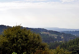
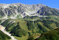
The Ushiro-Tateyama Mountain Range Area
This area is located in the northern part of the Northern Japan Alps, which were formed because of a very fast upheaval. Mt. Shirouma, whose altitude is 2,932 meters, is the highest peak in this area. While the west side of the mountains is comparatively gentle, the east side falls sharply. The alpine plant and the ptarmigan, which are survivors from the Ice Age, live here.
Mt. Asahidake Geosite
This geosite is a high-mountain zone and Mt. Asahidake, 2,148 meters high, is the main geopoint in this geosite. The features of this geosite are steep topography and alpine plants, and you can observe rocks of the Hida Marginal Belt (sedimentary rocks and serpentinite of Palaeozonic).
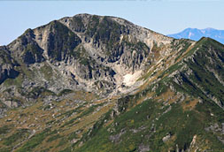
Mt. Hakubadake Geosite
Mt. Hakubadake, 2,932 meters high, is located at center of this geosite and includes Mt. Yukikuradake and Mt. Yarigatake. While the west side of the mountains is comparatively gentle, the east side falls sharply. Various alpine plants grow here.
The area is composed of Paleozoic sedimentary rocks and serpentinites of the Hida Marginal Belt.
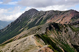
Mt. Kashimayarigatake Geosite
This geosite includes Mt. Karamatsu, Mt.Goryudake and Mt. Kashimayarigatake, which is the highest peak in the Ushiro-Tateyama mountain range.
You can observe the Kurobegawa granite, which evidence the very fast upheaval of the Northern Japan Alps.
Asahi Area
This area includes the Asahi nature park in the northeastern part of Toyama Prefecture. You can observe layers and fossils formed at the continent along the Sakai River. You can collect jade, which is a tourist attraction, on the seashore.
You can experience the ancient romance by watching the fossils from the age of dinosaurs and jade.
Jade Coast Geosite
This geosite includes the jade coast indicating beach erosion. There are many types of stones on the Jade coast; therefore, this geosite is the best place to learn about stones. You might be lucky to collect jade. An atelier of jade was found at the Hamayamatamatsukuri remains.
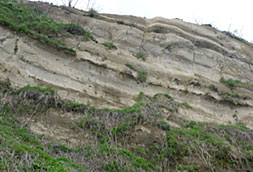
Sakai River Geosite
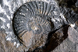
You can observe layers and fossils formed at the age when this geosite was a part of the continent. Plant fossils from the Tetori Group belonging to the Upper Jurrassic to Lower Creataceous system of the Mesozoic erathem in Japan are found along the Sakai River downstream. Fossils of marine animals such as ammonite are found in the sedimentation of Kuruma Group, which occurred in the early Jurassic Period of Mesozoic Era along upstream.
Ogawa Geosite
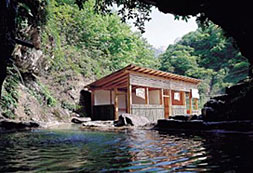
This geosite includes hot springs. You can observe travertine at Ogawa Hot Spring, fault outcrop and the Nanaedaki fall related to the Kurobishiyama Fault.
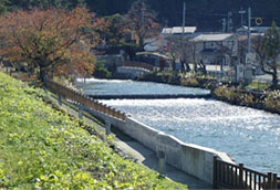
The Kurobegawa Fan Area
The Kurobegawa Fan was formed by sediment carried by the Kurobe River. It is a coastal alluvial fan with its toe located at the shore and plenty of ground water flow. Paddy fields with irrigation channels thrive on the fan.
The temperature of springs along the toe of the Kurobegawa Fan remains stable throughout all of the seasons. Groundwater supplies the Japanese cedar swamp at Sugisawa and the Amur sticklebacks (Pungitius sinensis, small fish living in cold water) in the stream. Residents use water for bathing and washing clothes. The forest was found in the sea off shore Nyuzen evidencing eustasy, or global sea-level changes.
The Alluvial Fan Springs along the Toe of Kurobegawa Fan Geosite
Geopoint, Nyuzen Town
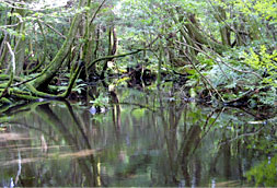
This geosite is located at the toe of the Kurobegawa Fan. Abundant and clean spring water sustains the Japanese cedar swamp at Sugisawa.
A submarine forest was found off the shore of Nyuzen, which evidences eustasy, or global sea-level changes.
The Central Kurobegawa Fan Geosite
God Geopoint
Various flood control methods can be observed at the center of the fan. Additionally, one can observe micro-landform units formed by flooding and study the history and culture of the Kurobe River, the development of the dispersed settlement, and the name of the settlement.
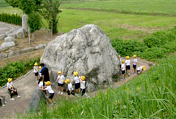
Funamino Geosite
Here, you can imagine the life in the Jomon period ? about 5,000 years ago.
The Top of the Kurobegawa Fan Geosite
The Kurobe River is the narrowest at the top of the fan because the substrate is very hard. For this reason, the bridge was built here to withstand the rapidly flowing stream. Settlements were also developed near here. This illustrates the deep relationship between water and residents of the region.
Jyunikanno Geosite
The Kurobe River has changed its route due to flooding and topographical changes. This geosite was the old Kurobe Rivergawa fan, but is now irrigated by a tributary of Kurobe River. This form of irrigation is called Jyunikanno irrigation. You can learn about the cultivation of a rice field during the Edo era and learn the ancestor wisdom regarding water use.
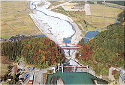
Kurobe Gorge Area
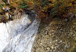
This area was formed by upheaval of the Northern Japan Alps and erosion of the Kurobe River, one of the steepest rivers in the world. The oldest zircon in Japan (about 3.8 billion years old) was found in granite, and the youngest granite in the world (0.8 million years old) was found along the Kurobe River. This signifies very active topographical changes in, and rapid upheaval of, the Quaternary Period. The Kurobe Dam is located upstream and supplied power to meet the high demand during periods of rapid economic growth in Japan.
Unazuki Geosite
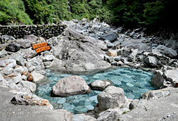
Staurolite, which evidences collision of the continents, was found here. 3.8 billion-year-old zircon is also produced in this geosite.It was made in the North China block originally. This geosite is the impotant place to think how the land has moved. You can enjoy the Unazuki Spa, which is the most popular hot spring in the Toyama Prefecture.
Keyakidaira Geosite
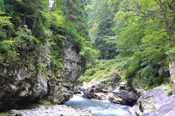
This geosite is located around Keyakidaira, a terminal of The Kurobe Gorge Railway. Here, you can observe erosion by the Kurobe River, exceptional scenery and an area of large-scale landslides.
Simonoroka Geosite
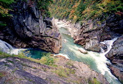
The Kurobe Gorge is deep and steep. You can enjoy spectacular scenery and learn about places relating to hydroelectric power production, including the Kurobe Dam and the hot tunnel.
Katakai River and Hayatsuki River Area
The world-class steep rivers like the Katakai River and the Hayatsuki River flow in this area.
You can also observe mine ruins at the upstream basin of both rivers. You can learn volcanic activity and creatures at forming the Japan Sea around middle basin of the rivers. Rice field and irrigation prevail in the downstream basin.
Plentiful groundwater also flows out at the toe of the fan; the buried forest was found under the ground which evidences sea level change.
Festivals relating to the sea have been passed down from generation to generation.
The Katakaigawa Fan Geosite
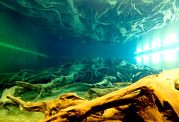
This geosite is composed of the Katakaigawa Fan Geosite and a terrace that was once a fan in the past. You can observe irrigation and enjoy foods like apples. The Uozu Buried Forest was found from ground in the spring zone along the toe of the fan near sea.
It evidences the sea-level change.
The Hayatsukigawa Fan Geosite
This geosite is composed of the Hayatsukigawa Fan. You can observe springs at the toe of the fan as well as numerous creatures. The Hayatsuki River flows into the sea steeply as in the middle basin. You can understand the steepness of the fan by observing rolling stones, plants and creatures in the river.
Tofukujino Geosite
You can observe a terrace of the old Hayatsukigawa Fan and layers formed at the Sea of Japan. You can learn about volcanic activity and creatures by observing layers from that time. You can also feel upheaval of the Hida Mountain Range on the terrace.
Mt. Sogadake Geosite
The shape of snow on Mt. Sogadake in the spring is said to look like a priest. You can observe how diverse plants have adjusted to the topography, seasonal wind in winter, snow and so on.
Katakai River Geosite
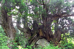
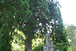
This geosaite is located at the middle and upstream of the Katakai River. You can observe the rocks of the Hida belt at the upstream basin, which evidences continental collision, layers in the middle stream basin at the time of forming the Japan Sea and old Japanese cedars Dosugi (big Japanese cedar growing on big rock) at another upstream.
Hayatsuki River Geosite
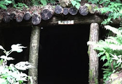
The Hayatsuki River and Kado River flow through this geosite. Four gold mine ruins of called seven Ecchu (old name of Toyama Prefecture) mines are located in this geosite.
Here, you can enjoy the popular scenery of Mt. Tsurugidake and glacial landforms.
Kamiichi River and Shiraiwa River Area
In this area, you can observe Hida gneisses and the Tetori Group in the upstream basin, shell fossils from the Cenozoic Era and the Kurehayama Gravel Formation in the middle stream basin and ancient tombs in the downstream basin.
Kamiichi River Geosite
at Kamiichi River Geopoint
You can observe Hida gneisses and Tetori group in the upstream basin and layers dating back to the Cenozoic Era in the middle basin.
You can also observe tephra in the Kurehayama Gravel Formation, which gives important hints regarding when the upheaval of the Northern Japan Alps began.
Shiraiwa River Geosite
Geopoint
The Shiraiwa River and the Ohiwa River flow through this geosite. You can observe ancient tombs in the downstream basin. Additionally, ponds formed by landslides are distributed in the upstream basin along the Ohiwa River. A Buddha figure from the Ohiwa-Nisski Temple is carved on a tuff face dating back to the Cenozoic Era.
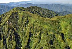
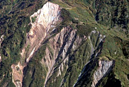
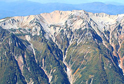
Mt. Tateyama Area
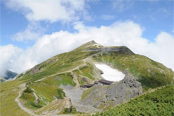
This geosite includes granites from various eras, a lava plateau formed by volcanic activity and the Tateyama caldera, which was formed by erosion. Reminders of the last glacial stage, such as glacial landforms, alpine plants and ptarmigan (a kind of bird) can be observed.
A glacier was recently found in this geosite and is the first glacier identified in Japan. You can see a 20-meter high wall of snow here in the spring, which makes this geosite a world-class place for snow.
Mt. Tateyama, Mt. Tsurugidake Geosite
Tateyama includes three mountains and Mt. Tsurugidake, which are composed of granite and constitute major mountains of Tateyama Mountains. There are also many prominent glacial landforms including cirques, glacial troughs and arete.
Three glaciers were confirmed in this area of Japan.
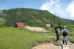
Murododaira Geosite
This geosite is a lava plateau formed by volcanic activity 40,000 years ago. You can observe explosion craters formed by steam explosions that have occurred on the plateau and in the region over the last 40,000 years. Tateyama Murodo is the oldest high-elevation mountain hut in Japan.
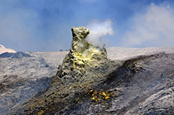
Tateyama Caldera Geosite
The Tateyama Caldera was formed by erosion and land collapses of the Tateyama Volcano. It is located to the south of Murododaira and Midagahara. The caldera’s diameter spans 6.5 kilometers from east to west and 4.5 kilometers from north to south. Tonbikuzure in the south of the caldera is one of three major landslides in Japan. There are also dammed lakes and hot springs in the caldera.
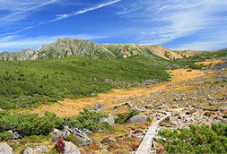
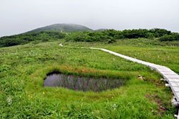
Midagahara Geosite
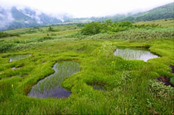
Midagahara is a 12 kilometers long welded tuff plateau that was formed by volcanic activity between 90,000 and 100,000 years ago.The Syoumyou River flows through it; Dainichidaira is on the right bank. There are about 1,000 Gakiden (marshponds) in the eastern area of the Midagahara Plateau. This area is a snowpatch grassland and was designated as a Ramsar Site in 2012. The western area of the Midagahara Plateau is covered with Tateyama cedars and beeches.
Bijyodaira Geosite
The western edge of the Midagahara lava plateau is called Bijodaida. Columnar joints (Zaimokuiwa in Japanese) made of lava and formed between 100,000 and 150,000 years ago are exposed along the old mountain trail to Mt.Tateyama.
Shoumyou Gorge Geosite
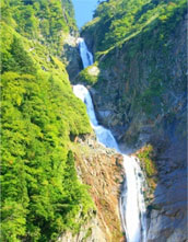
Shoumyou Falls has eroded the Midagahara lava plateau for 100,000 years and formed the Shoumyou Gorge. This is a natural sculpture curved by fire (lava) and water. The cliff on the left bank moving downstream is 500 meters high and 2 kilometers long. You can observe total snowslide, called an avalanche shoot, on the cliff.
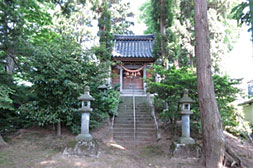
Joganji River Geosite
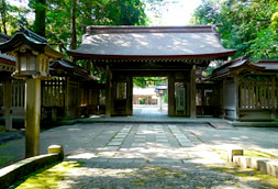
This geosite is located at the middle basin of the Jyoganji River. The Oyama Shrine, which is the symbolic place for the Tateyama beliefs (mountain worship), is located at center of this geosite. There are good viewpoints facing the Tateyama Mountains and Toyama Bay.
Arimine Geosite
Lake Arimine is located at the center of this geosite. People have lived in Arimine since about 600 years ago, but, due to dam construction, residents left here about 100 years ago. This area, which is designated as a prefecture nature park, is home to various plants from the sub-alpine zone through the mountain zone. The upper Jurassic to the lower Cretaceous Tetori Group (of the Mesozoic Era) is identifiable throughout the lake.
You can also observe the Atotsugawa Fault system.
The source of Kurobe River Area
Kumonodaira, a lava plateau formed by Mt. Sofudake’s eruption, is a major area in this geosite.
You can obserev glacial topography such as Goromaru kar and huge cliffs eroded by the Kurobe River. You can enjoy topography and geological features formed by fire (fever), ice and water.
Mt. Yakushidake Geosite
Mt. Yakushidake is a big mountain and a main area in this geosite. You can observe many cirques on the east side of Mt. Yakushidake, which indicates that glaciers existed here in the past. Mt. Yakushidake is an object for mountain worship.
Mt. Yakushidake is mainly composed of the Tetori Group and Paleogene volcanic rocks.
Kaminoroka Geosite
This geosite contains steep and big cliffs made of granite stands on both side of the Kurobe George at the upstream basin. Many river-trekking fans visit here.
Kumonotaira Geosite
This geosite is a lava plateau formed by the volcanic activity from the Early to Middle Pleistocene epoch in the Quaternary period, Cenozoic era, and is called the last unexplored region in Japan.
You can observe various alpine plants and beautiful natural scenery such as a garden composed of marshponds and volcanic rocks.
Mt. Suisho-dake Geosite
This geosite is a mountain zone above 3,000 meters and includes Mt. Suisyoudake and Mt. Noguchigoro-dake.
You can observe glacial cirques and horseshoe-shaped moraines on both mountains.
Mt. Kurobegoro-dake Geosite
at Geopoint
Here, you can observe glacial topography such as the Mt. Kurobegoro-dake cirque formed in the last glacial stage and several alpine plants. The top of Mt. Mitsumatarengedake is the prefectural boundary between Toyama, Gifu and Nagano.
Mt. Kitanomatadake Geosite
This geosite is a mountain geosite including Mt. Kitanomatadake and Mt. Terachiyama.
The upper Jurassic to lower Cretaceous Tetori Group of the Mesozoic erathem is distributed here.
You can observe patterned grounds such as glacial landforms on Mt. Kitanomatadake.
Toyama Plain Area
This area is composed of plain and alluvial fan formed by the Jyoganji River, one of the steepest rivers in the world. Kurehayama Hill upheaved by Kurehayama Fault is located in the western area.
Here, you can conduct studies on flood disaster, flood control, active faults, earthquakes and pollution diseases.
Jyoganjigawa Fan Geosite
This geosite is related to the Jyoganji River because of the bank constructed by a feudal lord named Satsa Narimasa in 1580, the Jyosaiaikuchi irrigation channel etc. The Jyosaiaikuchi irrigation channel supplies water to Toyama Plain. Tateyama Mountains and Toyama Plain can be seen from ‘Broader area of Toyama District Clean Center Observation room’in the middle basin of the Jyoganji River.
Middle of Jyoganjigawa Fan Geosite
This geosite is related to the history of disasters caused by debris-avalanche, flood and flood control. The rolling stone at Oba Geopoint reflects the intensity of the debris-avalanche.
A traditional bank called Kasumi Bank was constructed to neutralize flood.
Syogen Temple was a place where people prayed for safety from flood disasters.
The end of Jyoganjigawa Fan Geosite
Here, you can learn how the people utilize the river. Toyama Castle was surrounded by the Jinzu River in the past and was therefore known as “The Floating Castle.”
Tateyama Mountains and Toyama Plain can be seen from ‘Toyama City Hall Observation tower’.
Kurehayama Hill Geosite
Geopoint
Here, you can observe inclined layers formed by fault activity and the Kurehayama Gravel Bed that is alluvial fan deposit in the Quaternary period and evidences upheval of Hida Mountain Range.
The shell mound along the lagoon that spread during the Jomon transgression was found in the northwestern toe of Kurehayama Hill.
Skeletons of 91 humans in the early Jomon period were found in the Odake shell mound.
You can learn about the pollution disease caused by cadmium by observing the monuments memorializing restored rice fields.
Jinzu River Area
The Jinzu River flows through this geosite. You can observe dynamic diastrophism such as lava, thrust fault, anticline and syncline forming at the Sea of Japan.
The largest-class dinosaur footprint site in Japan were found here and date back to the lower Cretaceous Tetori Group of the Mesozoic Era. You can also observe strata and fossils from the era when the region was part of the continent and the Japan Sea was expanding.
Inotani Geosite
Jinzu George, which was eroded by the Jinzu River, is a major geosite. You can observe anticline and syncline at Inotani, which was formed by the folding of the Lower Cretaceous Tetori Group of the Mesozoic Era, and feel the power of the Earth. The site of the Inodani Checkpoint in the Edo period was an important point on the Hida Road between Toyama and Hida.
Nirehara Geosite
The Nirehara Formation consists of alluvial fan deposits created before the spreading of the Sea of Japan. Layers of lava and tuff were formed by volcanic activity during formation of the Sea of Japan, a thrust fault at Yokoyama-Nirehara and crustal movement.
Dinosaur Footprints Geosite
About 500 footprints of dinosaurs and birds were found in this geosite. This is the largest outcrop of fossil dinosaur footprints in Japan.
Footprints of ankylosaurid have only been found here and at another site in Toyama, Japan.
Yatsuo ?Yamada Area
Many (Cenozoic) Neogene fossils have been found in this area. Fossils of creatures that lived in mangroves in the subtropical zone, the deep sea and the cold-current sea have been found.
Here, you can learn about the history of the changing environment.
Yatsuo Geosite
Many Miocene fossils of the Neogene strata have been found in this geosite.
Fossils of creatures that lived in mangroves in the subtropical zone, the deep sea and the cold-current sea have been found here.
Yamada Geosite
You can observe strata and fossils from the Miocene to the Pliocene at this geosite.
Fault topography (landform) along the Kurehayama faults can be observed at Okanoyume Farm.
Shirakimine Geosite
This geosite is composed of uplifted peneplain mainly comprising Hida metamorphic rocks.
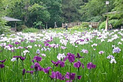
Many hikers enjoy watching the Hemerocallis middendorffii (Amur daylily) bloom on the marsh during summer.
The so-called ‘gaki-ta' (marshponds) also dot the landscape.
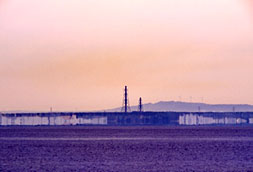
Toyama Bay Area
Toyama Bay is more than 1,000 meters deep and is located next to Ssuruga Bay and Sagami Bay.
Here, you can observe mirage and firefly squids. Various creatures live in Toyama Bay because many rivers flow into it and make itnutritious.
Mirage and Firefly Squid Geosite
You can observe unique natural phenomenon in Toyama Bay such as mirage and creatures such as firefly squid.
The views of Tateyama Mountains and Toyama Bay from here are exceptionally beautiful.
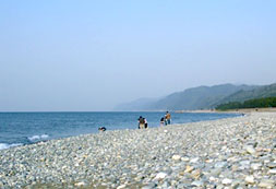
Iwasehama Beach Geosite
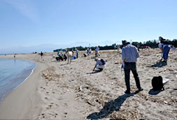
This is a seashore geosite surrounding Iwasehama Beach. The view of Tateyama Mountains from here on a clear day is exceptionally beautiful. You can observe that massive firefly squids going toward the seashore for spawning in the spring night. After laying eggs, they end their short lives on the beach. It is mysterious.